Leicester doesn't have the station it deserves. It's been dealt the misfortune of being on the Midland Main Line, the red-headed stepchild of the British rail network, constantly on the verge of getting electrified but never actually happened. Oh, they'll announce it, they'll make plans for it, then another branch of Government will turn up and say "this might cost some money - perhaps we could do nothing instead?" Theoretically it's going to be wired up to Sheffield at some point, but I imagine if you live in Sheffield you're permanently in a Jennifer Lawrence OK GIF state.
I headed down to the platform level. There are only two islands, with four tracks; it's a through station with no terminating spaces. It doesn't feel big or busy. Of course it is - five million passengers a year - but it feels like a pass through place, rather than a destination, or somewhere to change trains. Sheffield, which has a similar position on the railways, is far more lively and exciting. There are plans to rebuild it, with a new entrance to the side and a pedestrianised plaza and, yes, a proper station sign, so maybe things are about to change. (Please see the earlier paragraph about the Midland Main Line).
My first stop was... hmmm, where was it again?
The platforms at South Wigston are splayed either side of a pedestrian bridge and the walls of it have been painted by a local community group. It's very "inspiring", very "motivational", with messages about "kindness" and "love" and I'm afraid my cynicism circuits just overloaded. It's all very nice for the people painting it, I'm sure, but has anyone ever seen one of these murals and thought "I was going to murder someone today, but thanks to that child's picture I've decided to embrace happiness instead". I suppose it stops the local youths from layering the brickwork with obscene graffiti, so there's that.
I passed a small municipal car park and was surprised to see that I was now in the Borough of Oadby and Wigston. Leicester station is actually the only station in the entire city, which seems mad. The railway is long and straight and goes from one side to the other and they couldn't find space for one or two suburban stops to help commuters? Even more mad, South Wigston only opened in 1986.
I turned south, past "The Midlands Friendliest Training Centre" (yes it does need an apostrophe), and turned at the traffic lights to walk out of town. It was eerily quiet. Perhaps it was the layer of mist blocking the horizon from sight, but Wigston felt silent. This was, allegedly, a B road, a major through route, and yet there were hardly any cars, and definitely no pedestrians. Even a high school seemed deserted.
I enjoyed the detail on that link above that the train was rumoured to be there to support reopening Blaby railway station, only for the owner to say no, I just like it.
On the other side I clambered over one of the highest stiles I've ever encountered - I think my leg had to go full can-can to surmount it - and then followed a small alley round the back of some houses. A thought suddenly popped into my head: what if I get mugged here? I didn't really know where I was. I didn't know the area. It looked like a boring residential district, but who knew - this could be the Leicestershire equivalent of South Central LA, with crack addicts lurking in every nook. It says something about my complete lack of self-esteem and personal value that my first thought wasn't "what if I'm hurt or killed?" but was instead "what would I do about the blog if they nicked my camera?" I mean, I'd still have actually visited all these stations. But without the photographic proof, did it actually count? Would I have to come back to Leicester and do it all over again? I made a mild mental note to see if there's such a thing as a camera that constantly backs up to the cloud.
There was a printed notice on a lamp post asking me to Snub the Hub. This was the third one I'd seen; emotions were obviously running high about something. A little light Googling reveals that there are plans for a new logistics hub in Enderby and the locals are furious about it. I thought they might have a point; I imagined that little stone bridge I'd walked across being picked up and replaced by a massive warehouse. Perhaps they could sell it to an American, like London Bridge? Looking at the actual proposed site, however, it turns out to be further north, near an existing business centre, next to a park and ride, and backing onto the M1. It is, in short, exactly where you should put logistics hubs, and I'm afraid I'm unsympathetic that some people are going to have a little less grass to look at.
A sign informed me that I'd entered Glen Parva, which is a magnificent name for a district. It sounds like a distant Roman outpost for particularly unruly centurions. This was very much the edge of the village, the southern fringes, with the main body on the other side of the railway line. That was where the also magnificently named Eyres Monsell estate was, as well as the huge HMP Fosse Way. Here it was semi-rural, the edge of the city, where you detected there were drab fields hiding behind back gardens.
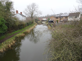
There was a noticeboard, with photos of the local councillors smiling at the camera in a pub somewhere, and a telephone exchange in grey concrete showing its age. It looked abandoned so I was surprised to see BT vans parked at the side. I wondered how much of the exchange was actually in use now we live in an age of digital switching and fibre optics. A bridge took me across the canal, walking in the opposite direction to a pair of bickering dog walkers, and then the traffic ground to a halt for some roadworks, undertaken by a firm designed to taunt me, specifically.
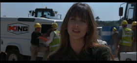
The firm in question was King Industries, and as you're a normal person and not a 007 obsessive, I should explain that King Industries is also the name of the villain's company in The World Is Not Enough. They're building an oil pipeline from Azerbaijan to the Mediterranean, and several scenes are set at their worksites and headquarters. And here's the thing: that's the logo they use in the film. That one, up there, on the side of that van.
See? There's Sophie Marceau being all villainous with the logo right behind her. It's identical. I couldn't decide if they were being cheeky and simply copying it (the company was founded in 2008, nine years after The World Is Not Enough was released), or if some graphic designer had charged them good money for something he ripped off a DVD. Either way, I was incensed. I felt like phoning Barbara Broccoli to tell her someone was exploiting her intellectual property and she should charge them (she needs the money, you see); at the very least I thought I should warn Leicestershire County Council that their highway works may be a front for a nefarious scheme involving oil rights and King Industries might be about to explode a nuclear bomb underneath Blaby.
Who knew that a blog about railway stations could somehow get even nerdier and more tragic?
I walked through the last dregs of Glen Parva, a road with houses on only one side, a retirement village, then a turn south towards Blaby. I was mildly intrigued to spot a steam engine on blocks in a field. Because this is 2024, and everything is on the internet, I can report that it was "WG Bagnall Works 2370 0-6-0F", and therefore sound a little bit like I know what I'm talking about for once.
The traffic in Blaby was directed down a dual carriageway bypass, but I pushed on, into the town centre itself. It was spread around a crossroads, with more coffee shops than you'd expect, and not one but two shops named after people called Bott (Bott Handmade Sofas and Barry Bott Jewellers). There is of course nothing amusing about this whatsoever.
At the centre I turned right, passing a Chinese restaurant called Double Dragon which I assume is full of twins kicking the crap out of each other, and soon found myself back at the bypass. I managed to get round an oversized roundabout, passed a mobile butcher, then followed Enderby Road and its stream of houses. A line of traffic queued patiently for the recycling centre but I continued on the narrow pavement.
My plan had been to follow this road all the way to the next station, but my attention was grabbed by a Public Footpath sign pointing across a nearby field. Not only did it look like a shortcut, slicing the corner off my walk, it also looked a lot more interesting than the current route. I clambered over the stile and started trudging across the extremely wet and muddy field. It wasn't the smartest decision in the world, kicking brown sludge over my jeans and stopping myself from sinking too far into the earth.
I was actually walking across the former site of Enderby's water mill, and the stone Packhorse Bridge there dates from the 15th century. A six hundred year old structure sitting quiet and unnoticed in a field in Leicestershire. This is why you should always wander off the beaten path.
Walking under the motorway brought me to Narborough, as evidenced by a pretty village sign.
I'm embarrassed to admit that I initially thought those reeds at the bottom were sausages.
Narborough was the most charming of the districts I'd walked through so far; I could see why it had retained its railway station while other towns on the line had lost theirs. (Actually they did lose it for a couple of years in the sixties, until public pressure forced British Rail to reopen it). This was a proper little town, with all the amenities you'd expect, and good houses that would appeal to commuters to Birmingham or Leicester or Coventry. A stone parish church peeped over the rooftops while walkers paused on the pavement to chat.
I took a seat and quietly picked the mud off my jeans while I waited for the train. That was the last of the walking really. From here on I'd be killing time between trains rather than trekking. I hoped there was a pub.


No comments:
Post a Comment